Aerial Survey and Mapping Services
FlyBy Photos are a Galway based company specialising in the generation of geo-referenced Orthomosaics and Digital Elevation Models from aerial images obtained by Remotely Piloted Aircraft Systems (RPAS) often referred to as drones. We generate an optimum flight plan to capture ultra-high (4K) resolution imagery of an object or site which can range from 0.1 to over 100 hectares and once processed the data can be used to generate 2D and 3D models with survey level accuracy and point clouds from which accurate Length, Area, Volume, Cut/Fill, Elevation Calculations can be made and we also produce geo-referenced Digital Orthomosaic Tiff files which can be scaled and used with AutoCAD.
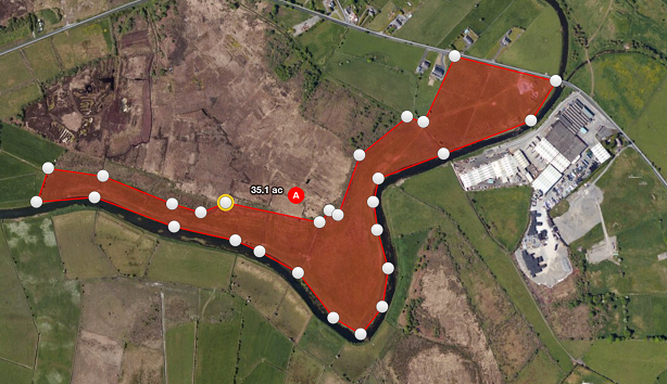
Here are a couple of examples of 3D model mapping.
Ross Errilly Friary (Ross Abbey) Galway Ireland
by FlyBy Photos
on Sketchfab
Farm 01 Simplified 3d Mesh
by FlyBy Photos on Sketchfab
We are currently working in conjunction with Mayo Fire Brigade Service on a project that is aimed to create an awareness of the capabilities and advantages of using RAPS technology to assist in our everyday work,
- Oil and Gas / Corridor Mapping and Monitoring
- Quarrying, Volumetrics
- Pipeline Monitoring / ROW / Insurance / Threat Assessment
- Powerline Monitoring / Infastructure
- Construction, Planning & Engineering
- Wildlife Management / Animal Counting
- Flood Management / Threat Assessment / Damage Assessment
- County / City Planning / Property Surveys
- Real Estate / Resort Planning
- Disaster Response (Oil Spills / Flood Mapping / Fire Mapping)
- Insurance / Damage Assessment / Residential, Commercial Rooftop Surveys
- Law Enforcement / Military Mission Planning
- Research / Academia
- Surveying / Mapping
- Environment Studies
- Archaeology
Aerial survey services are used everyday in the modern world, we can fly our aircraft in areas where full size aircraft can’t reach safely, in some cases we also use high resolution satellite imagery to bring you a detailed map of your subject or site.
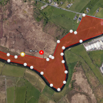
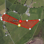
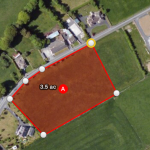
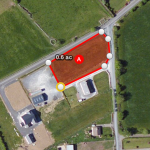
FlyBy Photos aircraft can be used to measure difficult to reach plots of land or sites, using the latest technology FlyBy Photos can verify the exact size or area of the site at a fraction of the cost a ground survey.
Aerial survey services can be used to plan land drainage, plot sizes or measure and pinpoint an exact point of reference.